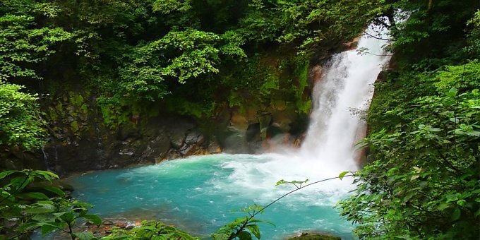
Rio Celeste and Bijagua
With spectacular turquoise blue waters and matching morpho butterflies fluttering around, natural hot springs and jungle trails that lead to one of Central America’s most stunning waterfalls, Rio Celeste (meaning Light Blue River in Spanish) is one of Costa Rica’s best kept secrets.

Located inside Tenorio Volcano National Park, legend has it that Rio Celeste got its distinctive color after God finished painting the sky and dipped his paint brush in the river. The more scientific explanation is that volcanic minerals produce the striking color. The river is born at a place called Los Teñideros, where two streams merge, causing a chemical reaction that is visible to visitors as the water changes from clear to an intense shade of blue.
For conservation reasons, bathing in the waters of this national park is strictly forbidden.
Despite Rio Celeste’s unparalleled beauty and a variety of options for accommodation in the area, including one upscale resort, this destination welcomes few visitors. In 2011, less than 24,000 people visited Tenorio Park. The reason for this is probably that the closest town to the park, Bijagua, is 40 minutes away on a very poor road. On the flip side, the park doesn’t get too crowded and preserves its natural state, which certainly adds to its allure.
The area that surrounds Rio Celeste is comprised of primary and secondary rainforest that is protected inside the national park. Tenorio Volcano, located within the park, has been dormant for years and a dense cloud forest covers its top. This area is home to many species of wildlife, including tapirs, monkeys, anteaters, sloths, wild cat species and a variety of exotic bird species, such as bell birds.
Tenorio Volcano National Park is open daily from 8 a.m. to 4 p.m. It is recommended that visitors enter by 2 p.m. at the latest so that they may cover the full extent of the trail before closing time. The entrance fee is $10 USD for foreigners and about $1.50 USD for Costa Ricans and residents.
Planning a vacation to Rio Celeste
We recommend a stay of two nights for visitors to the Rio celeste area. The main attraction is the waterfall, river, lagoon and trails, which can all be experienced in one full day.
There are several options for hotels in the Bijagua and Rio Celeste area. For mid-range accommodations we recommend Tenorio Lodge and Celeste Mountain Lodge. For more upscale accommodations, check out the Rio Celeste Hideaway Hotel.
Unless you are staying at the Rio Celeste Hideaway Hotel, which is located near the park entrance, we highly recommend a rental car with 4x4 for visitors to Rio Celeste and Tenorio National Park.
Reasons to visit
- This is one of the most beautiful and unique waterfalls in the Americas
- You want to visit an off the beaten path destination
- You enjoy hiking through the rainforest
- You enjoy eco-tourism
Reasons NOT to visit
- This is an off the beaten path destination that is not easy to access due to poor road conditions for the last 10 km
- It is at least 2.5 hours to the closest beach
- There is no nightlife
- It rains often (it is the rainforest after all)
- The trails within the park are muddy
- It is a jungle area, so there will be bugs, critters and creepy crawlers
How to get there
There are no airports in the Rio Celeste area, so you will have to take a ground transfer for access.
From San Jose: Follow the Inter-American Highway to Cañas, in the province of Guanacaste. Approximately 9 km after Cañas, take a right on Route 6 towards Upala until you reach the town of Bijagua. From there, follow the signs to Tenorio Volcano National Park.
Weather and packing list
Temperatures in Río Celeste usually hover between a refreshing 60 degrees at night to the upper 70s during the day. The rainy season here runs from May through June and September to November, with the heaviest rainfall generally expected in September and October. The dry season or verano in Spanish, usually extends from December to April.
Because the weather in Costa Rica’s Northern Zone is fairly unpredictable and torrential downpours can give way to sunny skies within minutes, visitors are advised to pack shorts, t-shirts, hiking gear, rain gear and sunblock. Throw in a pair of pants and a long sleeved shirt or light sweater in case the nighttime humidity makes you chilly. Check out our comprehensive packing list for more ideas.
Fun Fact: There is a local legend that when the Gods finished painting the sky, they dipped their paint brushes in the river creating the beautiful turquoise blue color.
Driving Distance
| San Jose | 210 km |
| Liberia | 84 km |
| La Fortuna and Arenal Volcano | 72 km |
| Monteverde | 111 km |
| Rincon de la Vieja | 100 km |
| Papagayo Gulf | 112 km |
| Flamingo Beach | 157 km |
| Tamarindo | 158 km |
| Samara | 169 km |
| Malpais-Santa Teresa | 217 km |
| Jaco | 185 km |
| Manuel Antonio | 253 km |
| Dominical | 291 km |
| Drake Bay | 457 km |
| San Gerardo de Dota | 297 km |
| Turrialba | 293 km |
| Tortuguero | 239 km |
| Puerto Viejo | 349 km |
| Sarapiqui | 154 km |
Attractions In The Area
| Tenorio Volcano | 1 km |
| Rio Celeste | 1 km |
| Cano Negro | 70 km |
| Rincon de la Vieja | 95 km |
| Arenal Volcano | 130 km |
Location
Latitude: N 10° 38' 38.4"
Longitude: W 84° 58' 39.72"
Unsure of what to do? Let us make you a free custom trip plan!
